Satellites on the Homestead
December 2, 2019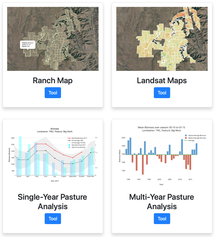
Ranchers have used farming tools for hundreds of years to manage their land, but now they’re using a more unconventional tool—satellites. The RangeSAT project is a collection of user-based web tools for ranchers & land managers that aims to improve land management practices for grazing. It uses vegetation information from satellite imagery to help farmers sustainably graze their livestock.
This project embodies collaboration between researchers, ranchers, and organizations in many fields. Northwest Knowledge Network’s Research Application Architect Jenifer Hinds is taking on the creation of the web tools along with Roger Lew from the Virtual Technology and Design Program in the College of Art & Architecture. Vincent Jansen, Jason Karl, and Crystal Kolden represent the College of Natural Resources Department of Forest, Rangeland and Fire Sciences, and are involved in researching and gathering data. The Nature Conservancy (TNC) is also a partner of this project, dedicated to helping ranchers make sustainable grazing decisions.
The preliminary project idea for RangeSAT started seven years ago, with Jansen, Kolden, and TNC wondering if it was possible to detect grazing patterns with satellite imagery. This question led to an initial study, which has evolved into the extensive analysis that continues today. In the initial stages, the project was focused solely in the Zumwalt Prairie in Eastern Oregon. More recently spreading to U of I’s Rock Creek Ranch, and across grazing allotments associated with the collaborative Grouse and Grazing Project.
RangeSAT is built from data collected by NASA’s Landsat project. The amount of available data is tremendous—in most areas of the globe, there is a satellite picture taken every two weeks, dating all the way back to the ‘70s. In addition to providing raw images, these satellite records offer multispectral data which can be used to infer growth and stress levels of vegetation. The new RangeSAT tools take the massive amount of existing data and filter it down to an individual management scale, allowing land managers to more efficiently apply the data, technology, and research available to them. According to Hinds, “these tools extract from a global data set meaningful information at a local scaleâ€.
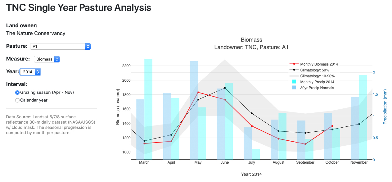
There are two types of tools currently offered on RangeSAT—maps and graphs. With the map tool, users can log in and see private visual information about their land, including biomass data on individual pastures. They can also view multiple types of vegetation indicators, like plant greenness and biomass—which informs decision-makers on the quality and quantity of vegetation. The graphing tools show statistics comparing the performance of specific pastures to previous year’s growth, as well as average data over time, so users can easily find trends. Climatological data, such as precipitation and air temperature, can be compared with the vegetation data so ranchers can see how the two are related and how they affect each other year to year. Both single-year and multi-year graphs can be viewed, which is helpful for extracting different kinds of information. Taking it one step further, combining climate and Landsat data “paints a more complete picture of the relationships between climate and the amount vegetation within a pasture or ranchâ€, says Hinds.
The RangeSAT web tools are in the beta phase of production and currently going through user testing. In future stages of this project, the creators want to collect and incorporate livestock grazing data into the online tools—another piece of the puzzle of how individual pastures perform and why. Another future aim is to enable a range of basic to advanced settings based on each user’s need and understanding. This way, the tools will be even more personalized and beneficial for individual land managers. RangeSAT will be live and ready for use in the early part of 2020. With plans to keep expanding and continuing research, the implications for this project are wide and far-reaching, not only for ranchers and landowners, but for researchers and policymakers as well.
This material is based upon work supported by the Natural Resources Conservation Service, U.S. Department of Agriculture, under agreement number NR193A750008G005, as well as funding provided by The Nature Conservancy and a Northwest Climate Hub Grant (FS agreement number 17-JV-11261944-073).
Project Members:
• Jennifer Hinds, Northwest Knowledge Network, IBEST• Vincent Jansen, Department of Forest, Rangeland and Fire Sciences, College of Natural Resources
• Jason Karl, Department of Forest, Rangeland, and Fire Sciences, College of Natural Resources
• Crystal Kolden, Department of Forest, Rangeland, and Fire Sciences, College of Natural Resources
• Roger Lew, Virtual Technology and Design Program, College of Art & Architecture
Partners and Sponsors:
• The Nature Conservancy• USDA National Resources Conservation Service (NRCS)
• USDA Northwest Climate Hub
• Bureau of Land Management
• Wood River Land Trust
Article by Katy Riendeau
IBEST Design & Marketing Coordinator